

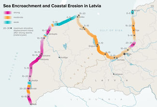
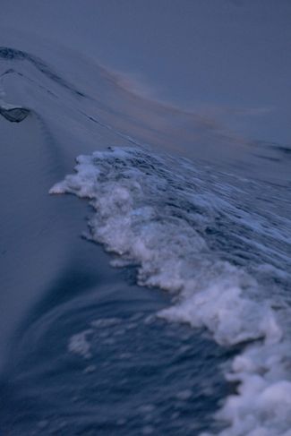
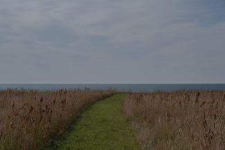
Along Latvia’s Baltic coast, the waves are gradually encroaching upon houses, trees, and historical landmarks — and while it’s possible to slow the degradation, the water can’t be stopped. According to geologists from the University of Latvia, the Baltic Sea has eroded an average of 37 acres of Latvian coastline every year for the last decade. The Latvian Environment, Geology, and Meteorology Center predicts that the country’s coastline will shift tens of meters inland by the end of the century. In some parts of the country, the sea’s advance has been a fact of life for millennia. But in the last century, human intervention and climate change have accelerated the process, disrupting local economies, cultural monuments, and natural landscapes — not to mention the lives of residents along the coast. In a special report from Latvia’s western Kurzeme region, Meduza photographer and photo editor Katya Balaban captures the country’s vanishing coast and all that’s being lost to the advancing sea.
The following is an abridged translation that appeared in The Beet, a weekly email dispatch from Meduza covering Central and Eastern Europe, the Caucasus, and Central Asia. Sign up here to get the next issue delivered directly to your inbox.
This dispatch from coastal Latvia is best enjoyed when accompanied by the sounds of the Baltic Sea. Click the player below to hear the waves.
One man versus the sea
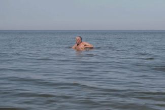
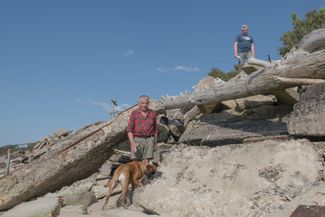
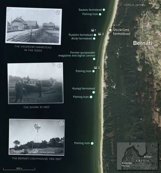
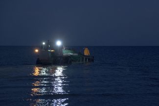
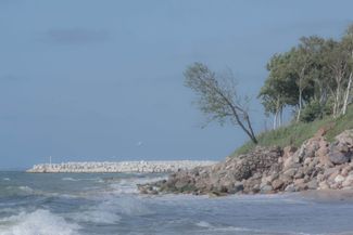
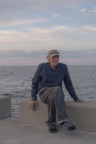
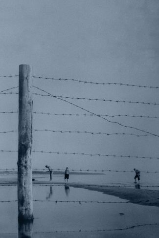
Standing in water up to his waist, Ernests Šliseris casts his nets into the sea; one more step and the water rises to his chest. Back in the 1930s, the Baltic Sea’s waters hadn’t reached here yet. Where Šliseris now catches flounder, villagers from coastal Bernāti and the Veckrūmi farmstead tended vegetable patches. When the sea drew too close in the 1940s, they rebuilt the farmstead’s house about 200 meters (219 yards) further inland. But the water followed them there, too, washing away buildings and gardens in its path.
According to local historian and former parish chairman Andris Maisis, the farmstead’s owners decided it was time to sell after Latvia recorded the strongest storm in its history on October 17–18, 1967. The waves were so high they beat against the windows of the house. Further north, in the city of Liepāja, wind gusts reached up to 173 kilometers, or 107 miles, per hour; tide gauges in the area recorded 1.74-meter surges and then broke.
“I bought the house in the summer and didn’t fully understand the situation. When autumn and the storms came, everything became clear. But I decided I would fight,” Šliseris recalls.
Back then, Šliseris worked in construction, hauling building waste. So, he started using leftover reinforced concrete slabs to fortify the shoreline near his new home. “Construction waste was taken to the forest,” he explains. “They told me, ‘take it to the woods’ and, well, I took it here instead. I did that for 15 years, until I retired.”
Šliseris’s home looks as though it sits atop a barricade that grew out of the sea. A wooden cross, found among the debris, towers over an iron staircase leading into the water. “I have my own exit to sea,” he says with a smile.
This makeshift breakwater keeps the waves from reaching Šliseris’s home, but they continue to eat away at the shoreline on either side, gradually turning his property into a peninsula. “To the right of the house, we had another half a hectare of land and a greenhouse, and there used to be a road out front. All of that’s already disappeared into the sea,” he explains. “Soviet border guards used to patrol that road every day — on foot, with dogs, and by car. They’d say to me, ‘What are you fighting against!’ But if I hadn’t fortified my home back then, it would’ve disappeared long ago.”
This is exactly what happened to the neighboring Kumpji farmstead. Perched just five meters (16 feet) from the water’s edge, the property belonged to a teacher from Liepāja, who used it as a summer home. For years, fishermen from the nearby village of Jūrmalciems had used it as a landmark when casting their nets for eels. Then, during a storm in January 1993, it was washed out to sea overnight.
According to old maps and Maisis’s research, the sea has swallowed roughly 200 meters of Bernāti’s coastline over the last century, inundating sand dunes, “sea gardens,” and woods, and washing away at least five farmsteads, a lighthouse, fishing boat docks, warehouses, and a defunct gunpowder magazine.
Bernāti is one of the southern points on Latvia’s Baltic coast where the sea’s advance is most intense. Researchers from the University of Latvia began monitoring coastal erosion along the Gulf of Riga in the late 1980s and expanded their work along the country’s entire seaboard after 1992. (During the Soviet occupation, the coastal area was a closed border zone.)
According to geologist Jānis Lapinskis, the researchers marked some 4,000 control points along the coastline and regularly measured their distance from the water's edge. This survey was conducted once or twice a year until 2010 but tapered off after the project lost funding. Nevertheless, students and teachers continue to take regular measurements and monitor the coast — now with the help of satellites.
This wealth of data collected over many years has allowed researchers to show just how far the sea is advancing in different areas and predict how the coastline might shift. According to their calculations, the Bernāti area could lose another 200 meters of coast to erosion by 2060.
Šliseris says he’s gone to bed “ready for battle” (wearing boots) more than once. During storms, the water batters his yard from all sides, making him feel as though he were “on a breakwater.” Since his retirement, Šliseris hasn’t been able to continue fortifying the shore near his home. (Moreover, such construction work has been prohibited since Bernāti was declared a protected nature area in 2004.) “I’ve done enough to last my lifetime,” he says. “And after that, it’s up to nature.”
The Latvian Climate and Energy Ministry’s 2024 roadmap for strengthening the seaboard and mitigating erosion in the South Kurzeme municipality offers a grim prognosis: “If strong storms continue at three- to six-year intervals, then in 30 to 50 years, the sea around the Bernāti cape will move another 200 to 400 meters further inland. The land on which the Veckrūmi house stands will first become a peninsula, then an island, and will ultimately be destroyed by the sea.”
Slowing the waves
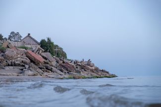
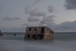
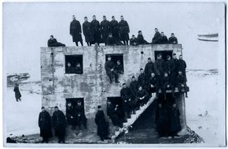
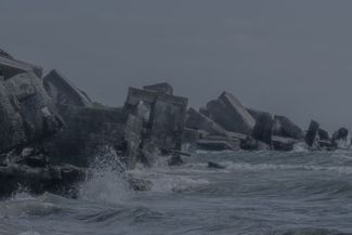
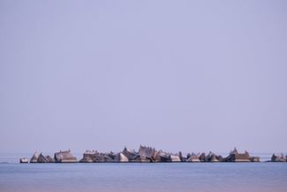
The massive concrete block vibrates from the impact, humming along with the waves like a gigantic seashell. Inside, it’s dark; the ground floor is flooded with muddy water, and sand slides underfoot. This two-story building is just one of the many forts and bunkers that form the Liepāja Fortress — part of the Karosta naval base built under the Russian Empire in the late 19th century.
“Even in the late 1990s, the fort was on the shore,” says local resident Sergey Dyundik. Today, the sea already surrounds some of the fortifications here, and the water level inside the buildings sometimes verges on human height.
The ruins are a monument to Latvia’s history and a local landmark. However, the information boards and tourist brochures warn that getting too close is dangerous. Due to coastal erosion, these multi-ton concrete structures may collapse, which happens especially often in winter, when the coast is waterlogged but doesn’t freeze. Without the protection of ice sheets, storms wash away the ground beneath forts, causing them to crumble and slide into the sea.
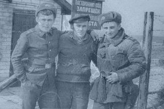
During the Soviet occupation, Karosta served as a submarine base for the Baltic Fleet. Though closed to civilians from neighboring Liepāja, this military area and army town was home to between 25,000 and 30,000 people. But after Latvia regained independence and the Soviet military withdrew, Karosta became a ghost town.
Almost everyone who grew up here has a story about their childhood adventures in the abandoned fortress. And they’ve witnessed the changes to the coastline firsthand. “I’ve lived in Karosta for more than 35 years, and I don’t even go there anymore,” says Irina, whose husband used to serve at the submarine base. “Before, you could climb up onto the roof to sunbathe; my children would climb up there. But now you can’t do that under any circumstances: the whole thing could fall down.”
“In January 2023, there was such a strong storm,” recalls Juris Raķis, a guide at the Latvian War Museum’s Liepāja branch. “I came to the shore, and at one point, I saw a piece of the fort tilt right before my eyes.”
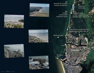
The Karosta district and the Liepāja Fortress are located in a multi-kilometer coastal erosion zone caused by human activity — namely, the construction of ports interfering with alongshore sediment transport. For 8,000 years, a 400-kilometer-long (250-mile) underwater “conveyor belt” has moved sand from south to north with each new wave, forming the underwater slopes and beaches along the Baltic Sea’s southeastern coastline. But the infrastructure of the Liepāja, Ventspils, and Pāvilosta ports are difficult obstacles for this multi-ton sand mass to surmount.
The Liepāja port’s piers and breakwaters, coupled with the constant deepening of its ship channel, have created a shortage of sand and a kilometers-long zone of man-made coastal erosion beyond its northern pier.
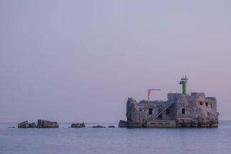
According to a 1915 map, the forts were located 30 to 50 meters (33 to 55 yards) and, in some cases, 100 meters (109 yards) from the sea. Now, these structures stand right at the water’s edge — or even out to sea.
Not far from the forts, another historical monument is at risk of disappearing — a Holocaust memorial dedicated to the thousands of Liepāja Jews massacred during World War II. The Šķēde dunes, where Nazi forces carried out mass killings, are still the site of common graves, and researchers uncover new execution pits every year. Lapinskis, the geologist, estimates that up to 150 meters (164 yards) of coastline has disappeared here since the early 1940s. “Some of the burial sites were probably washed away,” he says.
The shifting coastline is threatening the nearby Liepāja wastewater treatment plant, too. “[When] the treatment plant was built in 1972, the sea was 200 meters away. Every year, [it washes away] four meters on average. And if there are very strong storms, 10 meters or more can be washed away in one year,” the plant’s director, Vilmārs Bogovičs, told Latvia’s public broadcaster in 2018. “Where the coast isn’t fortified, we’re already becoming a peninsula.”
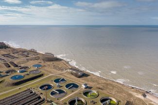
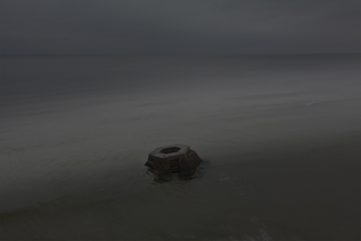
The fight to prevent an ecological catastrophe in the area has been ongoing for decades. The breakwater made of car tires that protected the shore in the 1980s was washed out to sea in the mid-1990s. The water also destroyed a 500-meter (547-yard) gabion built along the shore in 2005. In the 2010s, the treatment plant began reinforcing the shore with giant boulders.
All of these measures slowed the sea’s advance but didn’t stop it. “The coastal erosion process is quite aggressive. Since the Holocaust memorial and a critical infrastructure facility — the wastewater treatment plant — are located right on the coastline, the issue [of protecting them] has been and will be a constant problem for the city,” the Liepāja administration told Meduza.
In 2018, the sea was about 50 meters from the wastewater plant’s settling tanks and about 10 meters from its defunct chlorination station. Experts warned that all of this infrastructure could end up underwater in the next decade, along with the Holocaust memorial and, possibly, undiscovered mass graves. As such, the authorities set out to build yet another coastal protection structure.
The resulting 225-meter (246-meter) pier was completed in December 2022. (Originally estimated at 5.3 million euros, the construction costs grew to 6.4 million euros, with 75 percent of the funds coming from the European Union.) Judging by satellite data from July 2024, the structure has succeeded in pushing the water back 30 meters at the pier’s base and about 15 meters near the memorial. But the treatment plant’s facilities are still about the same distance from the sea.
The Liepāja administration did not respond to Meduza’s questions about the pier’s effectiveness or the cost of construction. However, they noted that a stone seawall is being built on the shore near the memorial and the treatment plant, to serve as an additional barrier against the waves.
Saying goodbye to the seaside
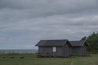
North of Liepāja, in the town of Pāvilosta, the Latvian government is set to launch yet another coastal protection project. Here, the city’s historic center, residential buildings, and hotels are under threat from the sea, which residents say has long been a source of trouble.
During the record storm of 1967, at least one house was washed away. “An old lady used to live where the restaurant is now,” recalls an elderly fisherman named Anton. “A big wave carried away her house in 1967. But she knew that this might happen and managed to get out.”
“Some years, during the storms, the water would come into [our] yards,” says Guntars, another Pāvilosta resident.
For years, locals had to take matters into their own hands; they built a rampart out of stones, but it started to wash away in 2015. Then, in an effort to stop the erosion of coastal dunes and prevent the flooding of homes, the municipal authorities joined forces with the Latvian Environmental Protection Fund to build a gabion along the shore in the autumn of 2018. Since 2019, however, renovations to the Pāvilosta port have undermined these measures, with the extension of its northern and southern piers intensifying coastal erosion, just like in Liepāja.
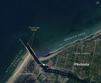
Audrius Skardžius, the owner of a seaside hotel, bought his property in 2006. It was 50 meters from the water’s edge at the time, but now one of his buildings is just 15 meters (50 feet) from the water. The effects of erosion have also made the seaside less attractive for tourists, with the water washing away the sand and throwing stones up onto the shore.
According to locals, vacationers are increasingly heading to the other side of the port’s southern pier, where sand has begun to accumulate, widening the shore. On the northern side, where the seaside houses and hotels are concentrated, the sandy beach has all but vanished. “Sometimes women with strollers can’t walk along this side of the shore,” Skardžius says. “I would really like for the shore to be strengthened somehow because the situation is quite dangerous.”
“You can’t do anything about nature, but the city should take care of people,” he adds.
According to local officials, the authorities have a plan to protect both the coast and people’s homes. A new proposal for safeguarding the Pāvilosta seashore was submitted to the European Regional Development Fund in January 2024 and has already made it through pre-selection. The Pāvilosta administration did not respond to Meduza’s questions about the project.
Latvian authorities aren’t legally obligated to protect residents at risk of losing their homes or land due to the advancing sea. Assistance for those living along the coast is entirely dependent on local authorities’ goodwill and initiative. The case of the village of Jūrkalne, located just north of Pāvilosta, is a prime example.
Collapsing cliffs
Every year, on Good Friday, Anna Rudīte Andersone goes to the shore before sunrise, throws a few handfuls of sand into the sea, and walks away without looking back. “I learned this from a woman who has since died, Marija Lāce, and she learned it from her father,” Andersone recalls. “They said this is how they managed to stop the sea. You have to believe.”
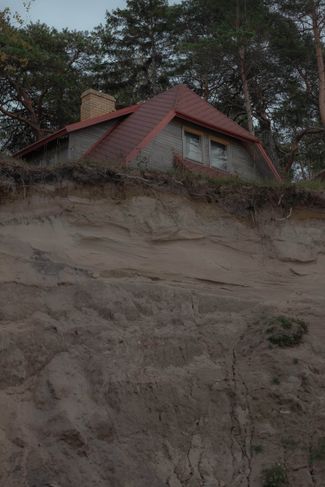
The Zitari farmstead, where Andersone has lived with her family for 45 years, is located on the steep coast of Jūrkalne, a village home to about 250 people. “The waves take everything they want. The sea comes right up to the cliff and washes away the land,” Andersone says, pointing towards the water. “I had hay sheds, but the sea has already taken them all. And the staircase to get down to the sea is also gone. Over the years, the cliff’s edge has moved about 70 meters closer.”
Several benches are near the cliff’s edge and a couple of summer cottages stand nearby. Andersone built the cottages for her daughters, who come to visit her in the summer. The rest of the time, she rents them out to tourists. “My parents tried to protect these houses by planting trees, but those trees are already in the sea,” says Anna’s daughter, Ilze. “Sooner or later, [the cottages] will have to be moved. We’ll see what happens in the fall.”
The buildings could be moved with the help of a crane, but the owners don’t plan to do this yet because it would be expensive and involve a lot of red tape.
Bureaucratic hurdles are also the reason the owners of other coastal farmsteads in Jūrkalne continue to pay tax on land the sea has washed away. “In theory, it’s possible to re-measure [the property] and make changes to the cadastral record in order to pay less,” says Māris Dadzis, the former parish chairman and owner of the Muižkalni farmstead. “But since the amount of tax would change minimally and remeasuring costs a lot of money, I don’t even think about it.”
Dadzis, who has lived in Jūrkalne for 60 years, says the sea has always been advancing — only the speed has changed. “For 13 years, it was calm. But three years ago, it started again, and it gets two or three meters closer each year.” Today, the distance from the cliff’s edge to the nearest building on Dadzis’s property is just 150 meters (164 yards).
For many years, Andersone couldn’t come to terms with the fact that her land is disappearing. She turned to government officials and experts for help, but nothing came of it. “I had plans like Napoleon!” she says. “I had so many ideas about what to do on the property and how to protect the coast. After all, my children and this land are all I have.”
Latvia’s 1997 Protection Zone Law is the only legislation that restricts development along the coast, but it does nothing to support the owners of coastal lots and homes that existed before its adoption. One such house in Jūrkalne, built approximately 40 meters (44 yards) from the shore in 1993, now looms over the cliff’s edge.
“There’s no precedent, I don’t know what [happens] in this situation,” says Jūrkalne parish Head Guntars Reķis when asked what assistance is available to the home’s owners. “This is a summer home and the owner is a rich man. Maybe the house is insured. The main thing is that the owner removes it in time, otherwise it will fall and all [the debris will be scattered] in the sea.” Geologist Jānis Lapinskis also says there’s “no roadmap” for what to do when a building suddenly finds itself perched on the edge of a cliff. “There are few structures like this and [developing] norms requires resources,” he explains.
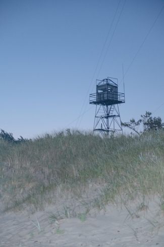
During the Soviet occupation, Latvia’s entire open sea coast, as well as the stretch from the Mērsrags Cape to the Kolka Cape in the Gulf of Riga, was a closed border zone dotted with watch towers and military bases. Entry was restricted and locals had to show a special passport stamp to prove they were registered residents of the border zone. Access to the seaside for swimming and sunbathing was limited to certain times and places, and you had to show your documents. “I still can’t swim because for half my life I couldn’t go near the sea,” says Dadzis. “To get to the beach in the summer, you had to drive several kilometers.”
The closed border zone deprived Latvians of access to their country’s natural resources, destroyed local ways of life, and interrupted centuries-old fishing dynasties — but it also averted a potential disaster. “We could have had a situation like in Riga’s Jūrmala, where there are buildings one after another on the shore. But because of the exclusion zone, nothing was built, so now, as a result, the [erosion of the coastline] is not so scary,” Reķis says.
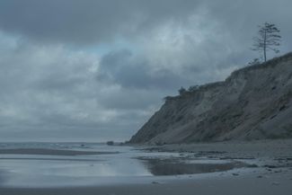
Stretching for 40 kilometers (25 miles), Jūrkalne’s steep coastline has been washing into the sea for thousands of years. As Lapinskis explains, the geological structure of the coast and the underwater slope, which contains a lot of clay, is particularly susceptible to erosion, and climate change is “intensifying this process.”
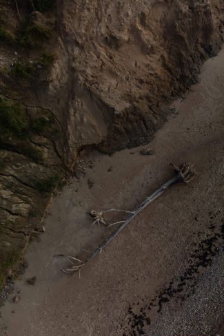
During a particularly large collapse in February 2020, roughly half an acre of cliffside crumbled overnight. “Huge chunks of land just fell off and were carried out to sea. When you see this, you understand how powerful nature is and that there’s nothing you can do about it,” says Santa Ansone, a local geography teacher who conducted coastal monitoring with her students for a decade.
The trees Ansone and her students used as control points were located on the other side of a road that ran past a former military base. “Recently, I walked through that place and realized that all our markers have long been in the sea. Now that road, the trees, and the military base are gone,” she says.
“I see the sea and its enormous power every day, and I’ve accepted that this process exists and that’s it. There’s no point in trying to stop it,” says Dadzis as he crosses his property and approaches the cliff’s edge. “There’s still enough [land] to last my lifetime and my son’s lifetime.”

A message from Meduza photo editor Katya Balaban
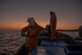
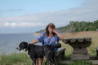
I’ve always been interested in stories about the relationship between people and nature. Perhaps because I spent the first 17 years of my life in a small town in the Urals, where man-made natural disasters occurred. One day, I came across a short article about the sea encroaching on Latvia’s coast, and I realized I wanted to find out as much as possible about this phenomenon. I set out to study a 100-kilometer (62-mile) stretch of the coastline in detail. As a result, I spent half the summer on my bike and on buses. Sometimes, the bus was also where I spent the night: the journey from my home to the coast takes four hours, and in order to accompany the fishermen going out to sea, I had to meet them at 4:00 a.m. At Meduza, we really love our work, and we often live the stories we tell. Please support our journalism.
Sign up for The Beet
Underreported stories. Fresh perspectives. From Budapest to Bishkek.