The fate of the Daugava How the fight to save a river gave rise to Latvia’s independence movement
Story by Katya Balaban for The Beet. Translation by Sam Breazeale.
In the aftermath of World War II, Moscow set out to build a cascade of hydroelectric power stations in Soviet-occupied Latvia. But popular opposition to the looming loss of natural monuments along the Daugava River proved to be a stumbling block — one that grew increasingly insurmountable as the decades-long project marched on. For The Beet, Meduza photographer and photo editor Katya Balaban recounts how the fight to save the Daugava River’s natural riches kick-started Latvia’s independence movement.
This story first appeared in The Beet, a weekly email dispatch from Meduza covering Central and Eastern Europe, the Caucasus, and Central Asia. Sign up here to get the next issue delivered directly to your inbox.
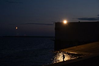
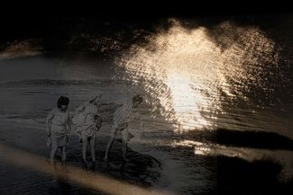
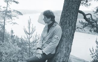
Every day in September 1974, Ādolfs Riekstiņš went to the bank of the Daugava River and watched as the massive pit that would soon become the Riga Hydroelectric Power Plant reservoir filled with water. Last to disappear were the remnants of the mill that his grandfather had built.
Ten years had passed since Riekstiņš’s family and nearly 200 others had learned that the Soviet authorities were planning to flood the land they had lived on for generations. “That was the first time I saw my dad cry,” Ādolfs’s daughter, Rudīte Ķikuste, recalled. “He and my grandfather had planted so many trees on the island. And now he was being ordered to chop them all down himself.”
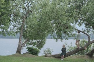
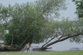
The Riekstiņš family had lived on Dole Island since 1740. Rudīte lived there for 18 years — almost up until the day it was flooded. She told The Beet that she learned to swim before she learned to read. For centuries, life on the island had been inseparable from the river.
The Daugava is the largest river in Latvia. Stretching a total length of 1,020 kilometers (634 miles), the river starts in Russia’s Tver region, crosses through northern Belarus, and continues into Latvia, where it flows into the Baltic Sea. The section in Latvia is 352 kilometers (219 miles) long.
The Daugava has always been important to the Latvian economy, and for thousands of years, it served as an important route for local tribes as well as for Vikings and European peoples, who used it for trade and conquest. Numerous settlements and castles arose along the banks of Daugava, some of which later grew into cities, including Riga.
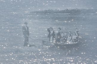
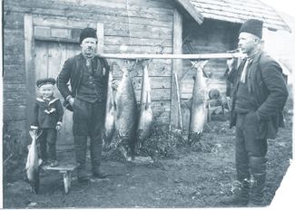
Every family on Dole Island had their own boats. Practically everybody fished, and many of the island’s residents mined dolomite from the river’s bed and banks. With no spring frosts on the island, conditions were ideal for agriculture. Islanders grew early potatoes and cabbage, wheat, rye, apples, and even grapes. Fish, vegetables, and stone were sent to the capital, Riga. Most households on the island were relatively wealthy; Rudīte’s grandfather, for example, had a mill, a smithy, a cattle yard, and several cargo boats.
“Everybody knew one another, and when you left home, you never locked your door,” Rudīte said. With a population of about 500, the island had a school, a library, a church, shops, a fire brigade (with its very own Ford), and even an orchestra; Rudīte’s father played the trumpet.


While the Riekstiņš family’s home disappeared underwater in 1974, it wasn’t the first time they had been forced to leave Dole Island. Decades earlier, during the mass deportations of 1941 and 1949, the Soviet authorities sent almost half of the island’s inhabitants to Siberia. “They expelled everyone who had anything at all,” Rudīte said. “My father gave his grandfather’s mill to the authorities to protect the family from repressions, but he ended up on their lists anyways.” Ultimately, the family managed to avoid deportation in 1949 thanks to one “conscientious Soviet officer” who advised them “not to be at home today.”
After Joseph Stalin’s death and the start of Nikita Khrushchev’s Thaw, the Riekstiņš family returned to Dole Island. They found their home occupied, but they managed to buy it back, and Ādolfs began working at the mill that had once belonged to his father. Twenty years later, they were forced to leave Dole Island again, when half of its territory was flooded.


The cascade
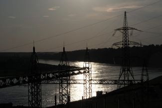
Engineers first proposed using the Daugava River to generate electricity in the 1920s, during Latvia’s interwar period of independence. According to historian Mārtiņš Mintaurs, an associate professor at the University of Latvia, the original plan was to construct a cascade of seven power stations between the town of Jekabpils and Riga, as well as to build passageways for fish and to develop the river for boat traffic. The reservoirs would remain within the main river bed, and the water level rise was projected to be minimal. By the end of the 1930s, however, only one station had been built: the Ķegums Hydroelectric Power Station.
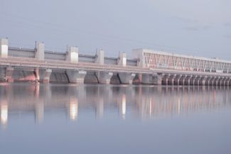
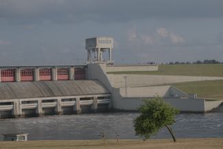
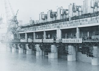
In the aftermath of World War II, during which Latvia came under Soviet occupation, the USSR’s Hydroproject Institute took over the project. The new, Moscow-designed plans included neither boat traffic nor fish passes, and instead of six more small stations, the authorities decided to build three large ones, each with a massive reservoir. The first new station, the Pļaviņas Hydroelectric Power Station, began operating in 1965; the Riga Hydroelectric Power Plant was built in 1974, and construction of a plant near the city of Daugavpils began in 1979.
Were these hydropower stations necessary?
Here’s what historian Mārtiņš Mintaurs had to say on the subject:
“Under the circumstances of an industrial era, building the HPPs was inevitable, but it could have been done in different ways. There were alternative projects. If it weren’t for the Soviet regime, this cascade could have been made according to the project from 1932: seven small HPPs, with small reservoirs. And then there would’ve been a different landscape. Of course, it would’ve generated less electricity than the Soviet project, but there would’ve been other benefits that weren’t taken into consideration in the Soviet era.”
The stations’ construction had a significant impact on the Daugava’s ecosystem. One of the biggest consequences was that the new dams disrupted the migrations of fish. “Initially, there was a plan to build a fish pass in the Riga HPP, but somebody came up with a so-called cost-cutting measure, and the fish pass was never built,” Mintaurs told The Beet. The power station presented an insurmountable obstacle for fish populations traveling back and forth from the Baltic Sea to spawn in the upper reaches of the river. Essentially, the entire Daugava, as well as the rivers and lakes connected to it that cover more than 60 percent of Latvia’s territory, was cut off.
The construction of the Daugava HPP cascade did immense damage to the local fish populations. According to official figures, the stations cause an annual loss of approximately 200 metric tons of salmon, 50 metric tons of sea trout, 70 metric tons of blue whiting, 50 metric tons of lampreys, two metric tons of eels, and 24 metric tons of other fish.
To compensate for the losses, the Latvian government’s BIOR Institute raises 6.3 million fish (eight different species) and releases them into the Daugava basin each year. These operations, which cost more than one million euros annually, are fully funded by the state-owned energy company Latvenergo, which owns the Riga, Pļaviņas, and Ķegums HPPs. (Latvenergo did not respond to Meduza’s interview request.)
At the same time, according to Didzis Ustups, the head of the Bior Institute’s Fish Resource Research Department, the three large hydroelectric stations, which provide about 70 percent of Latvia’s energy, have done less damage to the environment than the 149 small hydroelectric power plants on other rivers in the country: “Of course the three large stations have a negative impact, but they also provide [something positive]. Meanwhile, the 146 small power plants only provide about 1-2 percent [of the country’s electricity], while at the same time, they negatively affect about 1,000 kilometers (620 miles) of Latvian rivers.”
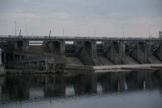
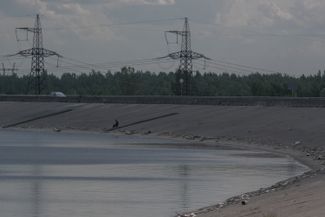
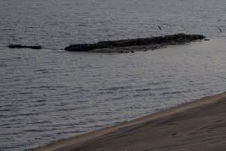
But the Riga and Pļaviņas HPPs didn’t just impact the local ecosystem; they also altered the landscape itself. Artificial riverbanks built along the shores of the Riga reservoir brought the water level up to about 10 meters (33 feet) above ground level. The reservoir spread over an area of 35 square kilometers (13.5 square miles). Dole Island, the largest island on the Daugava River, lost more than half of its territory, while the nearby islands of Mārtiņsala and Nulpe were fully submerged.
Residents who witnessed the Riga HPP’s construction said the territory of the future reservoir gradually started to resemble a “Martian landscape” or a “desert.” After the homes on Dole Island were demolished and the trees chopped down, bulldozers began to dig the pit, removing the top layer of soil from the part of Dole Island that was slated to be flooded. Construction work continued around the clock.
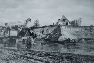
Vilnis Roze was born on the island and lived there until he was 20 years old. The future reservoir’s territory began behind his family’s garden. He saw with his own eyes how everything in the area was cut down, removed, and dug up; in his words, the process was “barbaric" and the residents “weren’t asked about anything.”
Bulldozers regularly encroached on the Roze family’s garden, Vilnis told The Beet. “They were massive — they looked like tanks,” he recalled. “I was 14 or 15 years old, and one time, late at night, when this vehicle came into our garden yet again, I climbed into its tracks to stop it from running over our apple trees.” The Roze family had lived on the island since the early 1700s. The house where Vilnis grew up and the garden he was determined to defend are still on the island today. His brother lives there now.
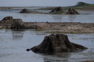
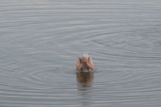
Once a year, Latvia’s state energy company, Latvenergo, drains the water from its HPP reservoirs for preventative maintenance work. In some areas, this reveals the stumps of felled trees and the foundations of demolished buildings.
‘A silent protest’
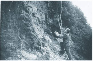
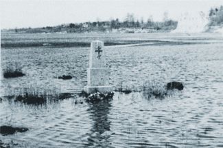
“I descended into the water; the visibility was very poor. In the dark, murky water, I saw the outline of a stone stage and benches for spectators. I joked to myself: if only we could organize an underwater concert,” recounted underwater archeologist Voldemārs Rains. In the 1990s, he and his colleagues made multiple dives to find out what had become of Staburags (or Staburadze), a natural monument that was once one of Latvia’s best-known cultural symbols.
Staburags was an 18.5-meter (61-foot) limestone cliff that appeared to “cry” from its numerous springs and that formed over the course of 10,000 years. It resembled the head of a bearded giant and was especially beautiful in the winter, when its white lime-rich springs would freeze. The site had inspired numerous legends over the centuries and Latvians traveled from all over the country to see it. Located next to it was Vīgante Park, which included a large platform and rows of benches. This was the stage that Rains saw while exploring the site three decades after it was submerged.


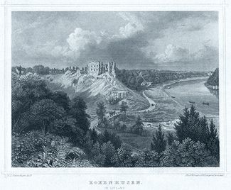
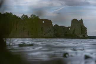
The construction of the Pļaviņas Hydroelectric Power Station in the 1960s entailed the flooding of other famous Latvian sites as well, including the Koknese Castle, which was built in the 13th century, as well as the nearby Pērse waterfall and the Oliņkalns Hill, which was the only training base for mountain climbers in Latvia and had the ruins of an ancient settlement on its summit.
During both the planning and construction stages of the Pļaviņas HPP, the prospect of losing these sites was painful for Latvia’s population and even led to open protests — something unthinkable during that era of Soviet rule.
Letters to the Soviet authorities opposing the construction of the Pļaviņas HPP were signed by biologists, archeologists, historians, mountain climbers, writers, journalists, artists, museum employees, and factory workers. “This project was developed by specialists who don’t know enough about the economic and cultural aspects of our republic [...] These sites, which belong exclusively to us, are part of our national character,” reads a 1958 letter from workers at Riga’s Popov Radio Factory to the Latvian Communist Party leadership. The public backlash delayed the construction of the Pļaviņas HPP by nearly five years, but the protests petered out after the Latvian Communist Party’s leadership was replaced in 1959. Construction began on the Pļaviņas HPP in 1961.
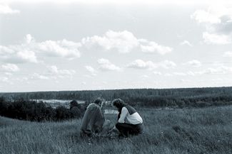
When it became clear that Staburags’s flooding was inevitable, people from all over the country began making pilgrimages to the site in what historian Mārtiņš Mintaurs called a “silent protest.” Archeologist Juris Urtāns visited the area several times during his childhood, before it was submerged. “People hiked along the Daugava, slept next to the river, and went out on rafts to preserve it in their memories however they could,” he recalled. Artists did their best to capture the cliff and the surrounding landscape that would soon be lost. Displaying a picture of Staburags became tantamount to flying Latvia’s traditional red-and-white flag, which was banned until 1988.
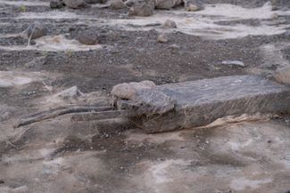
The only “compensation” for these losses that Latvia’s intelligentsia managed to attain were the large-scale archeological surveys carried out on the territory of the future reservoirs. “Everyone understood that we would lose a lot of cultural artifacts. The archaeological expeditions became rescue operations,” said Urtāns. During his childhood and adolescence, he had spent every summer performing excavations with his father, Vladislavs Urtāns, who took part in surveys during the construction of the Pļaviņas HPP and, later, the Riga HPP. “There had never been such large-scale excavations in Latvia and there haven’t been since, because they require an enormous amount of money,” Urtāns told The Beet. “Yes, we lost quite a lot on the Daugava River, but we also learned a lot.”
While the archaeologists increased the scope of their survey with every year of the hydroelectric plant’s construction, Urtāns estimates that they only managed to examine about 15 percent of Latvia’s archaeological cultural heritage in the flood zone of the Riga HPP reservoir, and even less in that of the Pļaviņas HPP.


‘The start of our revolution’
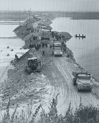
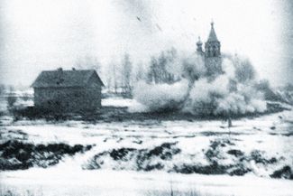
“This summer, at one of the most beautiful spots on the Daugava, the hamlet of Slutiški, one could observe unusual funeral processions. Excavators, bulldozers, and cars carrying human remains would travel the same path several times a day,” begins an article published in the newspaper Literatūra un Māksla (“Literature and Art”) on October 17, 1986.
By that point, the construction of the fourth station in the Daugava cascade, the Daugavpils HPP, had been ongoing for eight years. After moving a cemetery, multiple dacha communities, and an entire forest, the Soviet authorities had built access roads and temporary housing for hydraulic engineers, as well as a basin for the future reservoir and an embankment designed to serve as the dam. They planned to open the new station in 1990, but halted construction in 1987 — in no small part due to the article in Literatūra un Māksla.
In the article, titled “Thinking about the fate of the Daugava,” journalist Dainis Īvāns and water engineer Artur Snips called into question the benefit of the Daugavpils HPP and wrote about the damage it could do to Latvia’s economy, environment, and cultural heritage. The authors also criticized the technical and economic aspects of the project: Snips, who had previously worked at the Ķegums HPP, had managed to obtain the planning documents for the Daugavpils station.
Īvāns had spent the summer of 1986 staying with family in the Upper Daugava valley. “It had the most beautiful sites. Then suddenly I see these strange pegs hammered into the field. I started asking around, and it turned out that they were markers for the borders of the flood area,” he told The Beet. “I knew I had to do something.”
Īvāns and Snips’s article served as a trigger. “The day after the article’s publication, my apartment turned into the headquarters of the resistance,” Īvāns said. People began writing letters opposing the construction of the Daugavpils HPP; before long, 30,000 people had signed petitions against the station’s construction. A council of scientists convened several times at the Latvian Academy of Sciences to discuss the facility’s possible ramifications.


Members of the Belarusian intelligentsia got involved, as well. The water level in the Daugavpils reservoir was projected to rise by 20 meters (65 feet), which threatened to cause floods not only in Latvia but also in neighboring Belarus. The planned reservoir, stretching 200 kilometers (124 miles) wide, would have reached all the way to the city Navapolatsk.“Then an Eastern Europe-wide movement began. Estonians, Lithuanians, Slovakians, and Hungarians began coming to me to ‘learn from our experience,’” said Īvāns.
Two months after the article came out, the authorities tried to stop the protest wave by banning not only publications about the construction of the Daugavpils HPP but also any mention of the word “Daugava” itself. “It reached the point of absurdity. The June 17 Plant was ordered to stop producing a line of waffles that had a blue wrapper with the word ‘Daugava’ printed on it,” Īvāns recalled. In December 1987, the National History Museum of Latvia organized a photo exhibit on the Daugava River and Staburags. The Soviet leadership in Moscow ordered for the exhibit to be closed on the same day it opened.
To circumvent the censorship, musicians started singing about the river during concerts. “The word ‘Daugava’ became like a password,” Īvāns recalled. In May 1987, students from both Latvian and Belarusian universities traveled down the Daugava in boats with signs in support of preserving the river. Their route ended at the future site of the Daugavpils HPP, where they planned to hold a protest. “Fishermen” in gray suits stood all along the riverbank throughout their journey, and at the end they were met by the KGB chief and police officers. In response, the students sailed to the other side of the river and held their protest there.
By then, an unstoppable process had been set in motion. “Standing up for the Daugava meant the same thing as standing up for an independent Latvia. Many people know that the fight against the Daugavpils HPP was the start of our revolution,” Īvāns explained. “In defending the Daugava, people came to the realization that it was possible to stand up against the Soviet authorities.”
In the summer of 1987, the Soviet Academy of Sciences in Riga hosted a conference on environmental issues; the experts in attendance reached the conclusion that the construction of the Daugavpils HPP would be unacceptable on both environmental and economic grounds. On November 5, 1987, the Soviet Union’s Council of Ministers decided to stop the construction of the hydroelectric power plant near Daugavpils.
Less than four years later, in August 1991, Latvia declared full independence from the Soviet Union.
Sign up for The Beet
Underreported stories. Fresh perspectives. From Budapest to Bishkek.
Story by Katya Balaban for The Beet
Translation by Sam Breazeale