
‘This is not just a piece of land’ Viral maps show just how much of Ukraine’s territory Russia has seized
On May 29, Alex Bokoch shared a Facebook post that went viral. “For my European friends! Just keep in mind this area of Ukraine that has been occupied now by Russia, when you listen [to the] statements of your politicians,” he wrote.
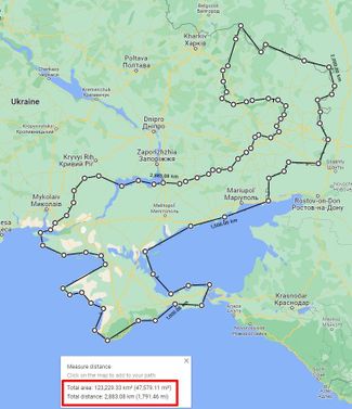
This message was accompanied by a map showing Ukrainian territory Russia has seized since 2014. According to the legend, this territory’s total area is 123,229 square kilometers (47,579 square miles) — equivalent to more than a fifth of Ukraine’s sovereign territory.
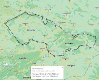
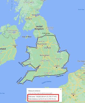
For comparison, Bokoch shared other maps that put this same area in the context of European countries, showing that 123,229 square kilometers is roughly half the total area of Germany or Italy, and the size of Switzerland and Austria combined. (You can see all of the maps here.)

Bokoch’s post racked up more than 2,000 likes and nearly 10,000 shares on Facebook. It also went viral on Instagram, after it was posted by a user named Olena Arkhypchuk.
“Feeling different when it’s your city itself?” Arkhypchuk wrote in the caption. “Please remember that this is not just a piece of land — people live there who have worked for half their lives, built/bought houses for themselves, life. And now they are held hostage by Russian occupiers.” (This appears to be a translation of a comment on the original Facebook post.)
Bokoch didn’t specify the source of the map data, or whether he created the maps himself. Various maps of Russian-controlled Ukrainian territory have been published by Ukrainian and Russian media, as well as by the Institute for the Study of War and UK Defense Intelligence. Ukraine’s Ministry of Social Policy also maintains a map of areas under Russian occupation and where active fighting is taking place.
In all likelihood, the mapmaker calculated this area by drawing the front line on Google Maps. Meduza did the same to check the accuracy of this calculation and arrived at an even bigger figure — 143,886 square kilometers (55,554 square miles). This is equivalent to approximately 24 percent of Ukraine’s sovereign territory.
When calculating the total area of Russian-controlled territory in Ukraine, Meduza included Ukraine’s territorial waters, which may explain why we arrived at a different figure. That said, Meduza would like to underscore that this is still an approximate calculation, since there isn’t a continuous “front line” and, in some areas, Russian occupation is limited to Ukrainian settlements.

Before February 24, the start of Moscow’s full-scale invasion of Ukraine, Kyiv calculated that seven percent of Ukraine’s territory was occupied by Russia.